Integrated space management enables effective planning, utilization and monitoring of premises, buildings, spaces and infrastructures in real time.
Space management integrates the spatial dimension into enterprise asset management. In plants, this is done by integrating CAD applications, while in the field map connections to graphical information systems (GIS) are used.
Improve the efficiency of maintenance and repair operations through CAD and GEO applications.
Minimize costs and labor by having companies schedule maintenance or repairs in advance.
Smooth communication and coordination with CAD and GEO applications, leading to better collaboration between teams.
The use of CAD and GIS in space management ensures compliance with safety standards and regulatory requirements.
Indoor and outdoor
CAD
CAD applications are essential for accurate and effective asset maintenance and repair. CAD software is used to create detailed 3D models of assets, which are then used to diagnose and plan maintenance and repair work. CAD applications also provide the ability to test different scenarios to ensure that repair work is performed accurately and cost-effectively.
GEO
Geo applications are invaluable in planning and performing maintenance and repair work on assets. With geospatial software, asset locations can be pinpointed and visually displayed, increasing efficiency and precision when performing maintenance and repair work. Geospatial applications also provide important weather and environmental data to minimize risks and enable optimal planning of maintenance activities.
Planning of spaces and buildings
The planning of the space inside and outside of buildings on time is critical. It enables the efficient use of resources, minimizes delays and cost overruns, and ensures the timely completion of construction projects. Accurate scheduling identifies potential bottlenecks early on, whether in labor, materials or machinery, and enables their timely resolution. In addition, effective scheduling promotes smooth collaboration between different trades and subcontractors, which improves the quality of work.
Identifying double occupancy conflicts in the same time period is critical to avoid bottlenecks and delays in construction projects. Timely identification of collisions in space utilization can avoid unnecessary costs and loss of time. At the same time, identifying synergies, for example by working in parallel in the same space, offers the opportunity for cost savings. Efficient planning and coordination are thus essential to minimize conflicts and at the same time increase the profitability of construction projects.
Scheduling is critical for construction phases, remodeling projects, and deconstruction projects. Numerous work steps must be coordinated within tight time frames and limited space. Careful scheduling minimizes delays, reduces costs and increases efficiency. It enables the smooth sequencing of tasks, ensures work safety and meets deadlines. It also creates transparency for everyone involved and facilitates resource allocation. Precise scheduling is therefore the backbone of successful construction projects and ensures effective use of the scarce space available.
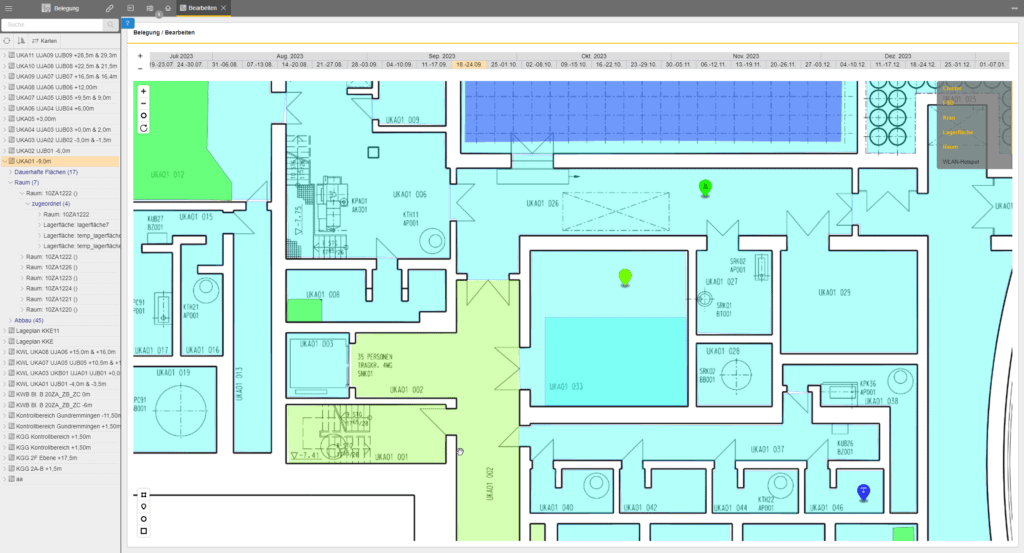
Indoor space management
One example of the use of CAD applications in enterprise asset management (EAM) systems is the creation of detailed designs for assets. CAD software is used to create accurate 2D or 3D models of assets and their components. This allows maintenance or repair work to be planned in advance, before it is carried out on the asset itself. The use of such models helps to minimize labor and costs.
CAD applications also improve collaboration between teams. By sharing CAD files, teams collaborate in real time and synchronize their work. As a result, they work more effectively and minimize the time spent planning maintenance or repair work. In addition, collaboration between different teams helps avoid errors or problems that can arise due to misunderstandings when planning maintenance work.
Indoor tracking is an emerging technology for accurate location tracking of people or objects in buildings. WLAN, Bluetooth, ultrasound, magnetic field positioning systems, UWB and RFID are used to achieve precise results. Applications can be found in healthcare, manufacturing and transportation, such as patient tracking, asset tracking, employee security, vehicle tracking and access control.
One example of the use of CAD applications in enterprise asset management (EAM) systems is the creation of detailed designs for assets. CAD software is used to create precise 2D or 3D models of assets and their components. This allows maintenance or repair work to be planned in advance, before it is carried out on the asset itself. The use of such models helps to minimize labor and costs.
CAD applications also improve collaboration between teams. By sharing CAD files, teams collaborate in real time and synchronize their work. As a result, they work more effectively and minimize the time spent planning maintenance or repair work. In addition, collaboration between different teams helps avoid errors or problems that can arise due to misunderstandings when planning maintenance work.
Indoor tracking is an emerging technology for accurate location tracking of people or objects in buildings. WLAN, Bluetooth, ultrasound, magnetic field positioning systems, UWB and RFID are used to achieve precise results. Applications can be found in healthcare, manufacturing and transportation, such as patient tracking, asset tracking, employee security, vehicle tracking and access control.
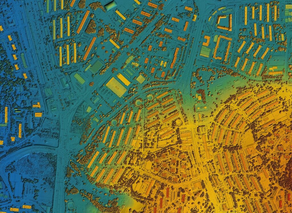
Space management in the open field
Especially when planning maintenance and repair work, the use of GEO applications is extremely valuable, as regional factors can be quickly taken into account. Integrating data from various sources, such as sensors, provides a more comprehensive picture of assets and their surroundings. This helps to make informed decisions and optimize the deployment of teams and resources.
Route planning is another important area where GEO applications are used. Spatial planning of team assignments and their staffing increases efficiency, travel times are minimized and processes are optimized. Conflicts in activities at the same assets are avoided. The visualization provides a high level of transparency for both the planned and the actual situation.
In addition to improving efficiency and productivity, the use of GEO applications can also help increase employee safety. At the same time, it reduces waiting times due to external conditions. Monitoring locations, integrating weather services and forecasting weather conditions make it possible to work in safe conditions and prepare for changes in the environment.
Our solutions and partners
We are long-standing solutions partners of market-leading EAM systems such as IBM Maximo and Hexagon EAM.